Forest Boundary Road climbs out of the Left Fork Rhodes Canyon area and works its way east toward the open shelf above Soapstone Basin. The route starts in a firewood-cutting zone where downed trees sometimes block the path, then breaks into the open with wide views down into the canyon. Once past the tree line, the dirt surface is exposed to weather and shows the washouts and ruts that come with it. Near the far end the road narrows to a single lane with no place to turn around, so most drivers treat the main viewpoint as the turnaround spot.
Trail Summary
- Location: Hanna, Utah (Duchesne County), off Highway 35 through Left Fork Rhodes Canyon
- Distance: 3.5 miles
- Difficulty: Level 3 - Best suited for a high clearance 4x4
- Minimum Elevation: 9,334 feet
- Maximum Elevation: 9,866 feet
- Elevation Gain: 417 feet
- Travel Time: 45 minutes to 1 hour
Difficulty
Best suited for a high clearance 4x4
A stock vehicle with high ground clearance, 4WD, and off-road tires is enough for this route. The road surface is mostly rock and undulating dirt, with occasional ledges, drops, or short climbs under a foot tall that call for careful tire placement. Loose sections and short steep grades show up in a few spots, and the trail is off camber in places. The single vehicle width with limited passing room near the far end adds to the difficulty on busier days.
Elevation
Elevation on this stretch ranges from 9,334 feet at the low point to 9,866 feet at the high point, a spread of about 532 feet. The overall trend runs downhill west to east, with 417 feet of climbing offset by 791 feet of descent, for a net drop of about 374 feet from start to finish.
Terrain
This is mountain shelf road country, running along a narrow bench above the canyon before settling into rockier two-track as it pushes east. Expect a packed dirt and rock surface for most of the drive, with washouts and ruts becoming more noticeable past the tree line where the road is fully exposed to weather. A good portion of the route runs through old burn scar from the Hanna Fire, with standing dead timber visible along both the early stretch and again near the shelf road further east.
4WD Experience
Traction is generally good on the maintained sections near the start, but the exposed dirt further in gets rough after rain or snowmelt. Large undulations in the road surface can require a fair amount of flex, and drivers without lockers may want to pick their line carefully through the rutted spots. The last stretch narrows to about 50 inches wide with no turnaround, so full size trucks should plan to stop at the main viewpoint rather than push further.
Travel Time
The recorded track covered the 3.5 miles in about 45 minutes of moving and stopped time combined. A high clearance 4WD vehicle taking it at a reasonable pace, with a few stops for the views, should plan on 45 minutes to an hour one way.
Highlights
Much of the drive, from the trailhead up through the middle section, cuts through old burn scar, later identified as the Hanna Fire. Blackened trunks still stand along both sides of the road in places. About two thirds of the way in, the trail opens onto a standout viewpoint looking down into the valley, with Highway 35 and a stretch of private property visible across the ridge. Past that, the road narrows onto a shelf cut into the hillside, with more burned timber visible across to the far side. The trail ends by tying into Left Fork Canyon Road. Dispersed camping is available near the first viewpoint for anyone wanting to stay the night, though sites are limited and exposed.
Trail GPS File
Map
GAIA GPS Track
Interesting Waypoints
Waypoint 1
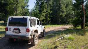
Trailhead marker confirming this is Road 528 (FS 70528).
Waypoint 2

Waypoint 3

Waypoint 4 (40.499553, -110.943156)

Waypoint 5 (40.498565, -110.940113)
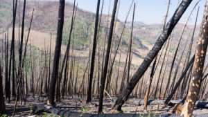
Much of the drive up to this point runs through burn scar left by the Hanna Fire.

Waypoint 6 (40.494823, -110.926655)
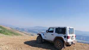
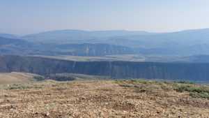
A standout viewpoint looking down into the valley, with Highway 35 and private property visible across the ridge.

Waypoint 7 (40.494800, -110.926584)
Waypoint 8 (40.494796, -110.926564)
Waypoint 9 (40.493451, -110.909333)
The trail narrows to a shelf road here, with burnt trees from the Hanna Fire visible across to the far side.
Waypoint 10 (40.493453, -110.909339)

Waypoint 11 (40.497528, -110.916024)
The trail ends here, tying into Left Fork Canyon Road.

Waypoint 12 (40.497530, -110.916021)

Waypoint 13 (40.497533, -110.916017)
